
Flood Plain Reduction Draft Map
 Launch the media gallery 1 player
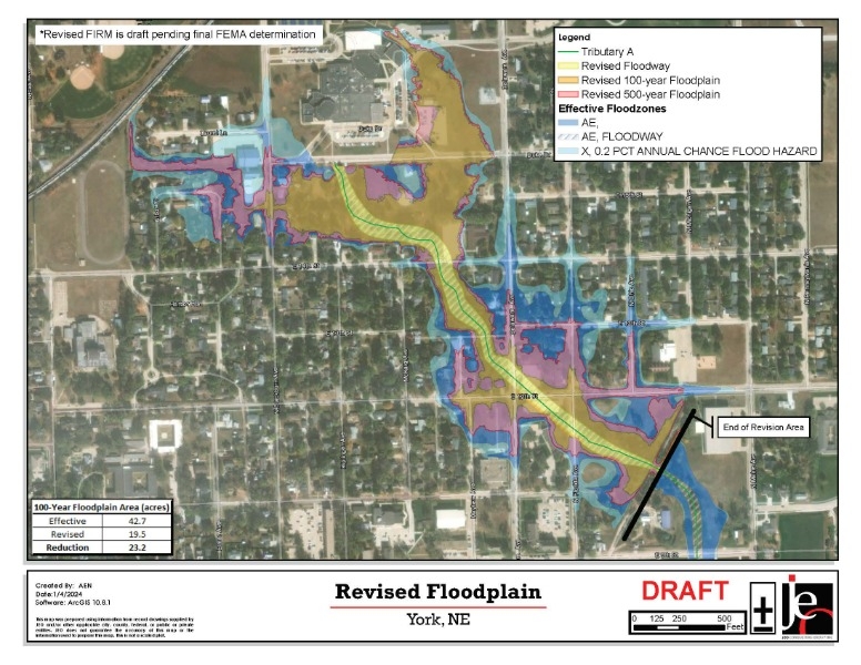
The City of York, NE (City) in accordance with National Flood Insurance Program regulation 65.7 (b)(1) hereby gives notice of the City’s intent to revise the flood hazard information on the Flood Insurance Rate Map (FIRM) for the City. The City is applying for a Letter of Map Revision (LOMR) from the Federal Emergency Management Agency (DHS-FEMA) to revise York County FIRM panels 31185C0190C and 31185C0302C for the City of York in York County, NE along Tributary A. Planned revisions along Tributary A are generally located between approximately 540 feet downstream of N. Florida Avenue to just downstream of Duke Drive. As a result of the revision, the floodway will narrow, the 1-percent-annual-chance water-surface elevations shall decrease and the 1-percent-annual-chance floodplain will narrow within the area of revision.
Maps and detailed analysis of the proposed revision can be reviewed at the City of York Municipal Building at 100 E. 4th Street, York, NE. Interested persons may call Dr. Sue Crawford, York City Administrator, at (402) 363-2600 for additional information.