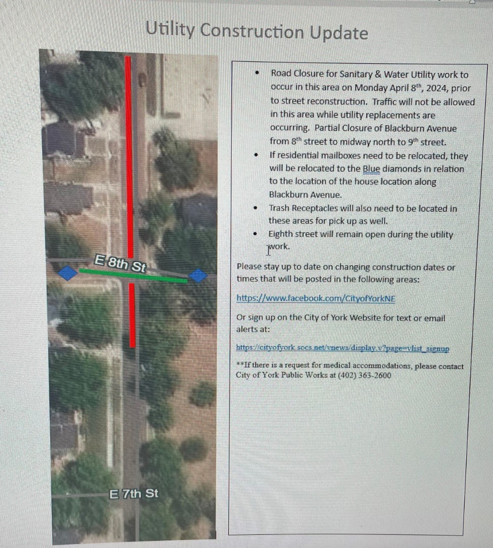
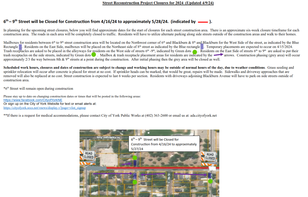
****UPDATE!!! Closure from 6th street to 9th street now scheduled to occur on Monday 4/22/2024.
This update is due to the recent weather events and is based on information gathered from the project contractor
A partial closure of the area for utility replacement is still in affect
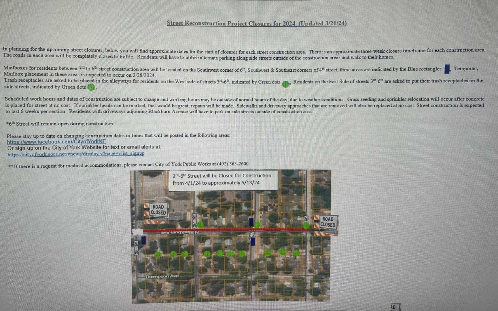
**Street Paving on Blackburn Avenue from 3rd to 6th street is expected to occur this Friday, 4/12/2024
Next Closure from 6th street to 9th street to occur on 4/16/2024. See posting below...
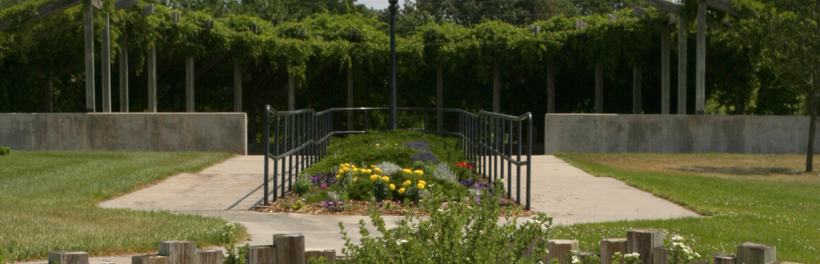
Project Access York
To receive notices of meetings and events - for Project Access York and other City happenings - sign up for the City of York app and activate notices.
Project Schedule
Grant Awarded - July 2022
Design Planning Community Day & Public Open House 1 – March 2023
Appointment opportunities for effected land owners to learn more about their specific property impacts - Late March 2024 (Effected landowners will receive certified letters with details on how to register for an appointment.)
Public Open House 2 – May 28th 2024
Documentation & Approval – June 2024 to October 2024
ROW Appraisals, Negotiations & Acquisitions – November 2024 – April 2026
Final Design Submittal – June 2026
Project Letting – August 2026
Construction - 2027 - 2028
Proposed trail maps will be available for comment at an open house scheduled for May 28th from 4:30 PM to 6:30 PM at the Holthus Convention Center. The open house will be the public release of the maps. After the open house, copies will be made available in other formats. If you need transportation assistance, please contact York Public Transportation (402) 362-7626.
Since the trail is a federally-funded project, there are over 20 approval steps required between March and the meeting at the end of May. All of these approval steps must be completed to release the maps for public comment. After the maps are released for public comment on May 28th, copies of the maps will be available on the website and at city offices.
The May 28th open house is the second open house in the trail planning process.
When the city no longer has use for a property, the property gets listed for on the city council agenda as property to be declared surplus. You can watch for surplus approvals on the city council agenda to see what property becomes surplus. The city contracts with Green Auction to auction off the property.
Large property, like vehicles, would be listed on the auction site here - along with other auction items.
Smaller personal property items, like tools or piano, would get listed here.

A reminder as we get into campaign, contractor, event, and garage sale season -
All yard signs must be placed on personal property. Generally this is the portion of the lawn behind the sidewalk. The area between the sidewalk and the street is city right-of-way. Signs are not allowed in the city right-of-way and may be removed.
Where are the 850 feet of school trail, 1,700 feet of Village 81 Trail and nine additional tracks listed on page two of exhibit A?
The proposed trail locations will become public information when the maps are released for public comment this spring. Information on how to access the information and how to provide public comment will be published in local news outlets, the city website, the city Facebook page, and the city app notifications.
Have any of you council members received clarification on these locations?
Yes. Council members have been briefed on the proposed locations.
Will I be notified that you intend to take my property for your trail?
Property rights in the form of permanent right-of way, permanent easements, or temporary easements would be required from portions of properties to construct and maintain the trail. Any property rights that are required will be negotiated directly with the property owner. The property owner will be compensated for the use or acquisition of property rights. In past similar projects, other accommodations, like fences have commonly been a part of the negotiation as well.
How did we get from no maps, to contacting property owners in one month?
The routes are still under review. Before maps of the potential routes are made public, the city and the engineers will meet with the property owners whose land the trail could cross. We want to give those landowners the courtesy of having a chance to review the proposed trail and talk with the engineers and the city before the maps become public.
Is the village 81 trail being a pedestrian trail or is that the bicycle trail?
In transportation discussions the word “pedestrian” often refers to any non-vehicle mode of transportation. The same word sometimes refers to people walking. The trail will be designed for non-vehicle traffic including bicycles and people walking.
Will this trail be an ADA compliant trail?
Yes.
Is the village 81 trail going to be lit? At what intervals?
The lighting options are a component that will be addressed as we get nearer construction. It is our hope that by that point solar trail light technology will be more affordable.
If a 14-year-old girl closes at McDonald’s in the winter time, will be riding back home in the dark or will the trail be lit?
McDonalds will not hire a 14-year-old to close, it would violate child labor protections. Parents will have full information about trail lighting so they can make responsible choices about their teenagers’ transportation needs.
Will there be any snow control? Is the city responsible? What is the priority?
Yes. The city will be responsible for clearing the trails in all locations. Between now and 2028 the city will clarify a snow removal workflow that includes how the trails are prioritized compared to other transportation corridors.
Is there any tree removal this April?
No. Not for Project Access York. Construction is not anticipated to begin until the spring of 2027.
Who’s going to control that kids will be riding on the trail at the 80/81 corridor and not riding on the service roads?
Parents are ultimately responsible for supervising 14 year old children. The city is working on a separate engineering project to improve safety for people of all ages and all modes of transit in the interchange so that there will be ways for people of all ages to safely get access to jobs, food, and shopping.
What’s the estimate by the city of how many people walk to and from interstate to town each day, week? When this trail is built, what the estimate would be on how many people would use it on a weekly, daily basis?
Data from a 2019 Census study projected that about 4% of York employees walk or bike to work. The benefit/cost analysis for the trail grant assumed a 2% increase per year for the first three years after construction. The benefit/cost ratio calculated for the Project Access York project with this assumption is 1.865. This means that the trail is expected to bring economic benefits to the community over the next 10 years of at least $29 million dollars.
Why would we put it in a poorly visible area, low accessibility?
Abandoned rail corridors are often used safely for trails. Trees that have overgrown those abandoned rail corridors would be cleared with the project opening up sight-lines for long distances down the trail.
What law enforcement has city council talked to?
A law enforcement representative was part of the original planning process. As we go through the stages of design law enforcement will be consulted for input. Law enforcement will lead discussions of security measures and policies for the trail.
Trail Safety Questions
Some questions and comments concerned the safety of the trail. The most recent study of rural trails found in a search for scholarly articles on trail safety was a study published in the American Journal of Preventive Medicine. This study of trails in 12 rural Missouri counties found that only 1% of the users perceived unsafe conditions[i]. Those results measure perception of safety. A study of 372 trails that measured crime on trails in an objective way compares crime rates on rural trails to crimes rates in rural communities more generally. It’s an older study, but it is a comprehensive and direct study of crime rates on rural trails. The study finds that in 1995 there were 19 muggings per 100,000 population in rural communities. That same year there were 0 muggings reported on rural trails. In that same year there were 203 assaults per 100,000 persons in rural communities and .01 assaults per 100,000 on rural trails[ii]
Clarification in response to questions related to the various roles of NDOT, Olsson, and the city.
NDOT’s role is to help us complete the federal grant project on time and to meet all federal and state transportation department requirements, including safety and public input rules. Olsson’s role is to design the project to meet the criteria of the federal grant and all federal and state transportation requirements. NDOT, Olsson, and the city all work together to help control costs on the project. Olsson is responsible for facilitating public input, analyzing the input, and reporting to NDOT, the city and the federal government how they responded to public input. The city council approved NDOT’s involvement and Olsson’s contract. The city council will vote to approve the final Olsson plan
[i] Brownson, Ross C. et. al. 2000. Promoting Physical activity in rural communities: Walking trail access, use, and effects. American Journal of Preventive Medicine. 18: 235-241.
[ii] Tracy, Tammy and Hugh Morris. 1998. Rail Trails and Safe Communities: The Experience on 372 Trails. National Park Service.